
EL NINO SOUTHERN OSCILLATION (ENSO) FORECAST
Updated As Warranted

EL NINO SOUTHERN OSCILLATION (ENSO) FORECAST
Updated As Warranted
Issued: 06/05/00
See ENSO page for Links and Current Data. ENSO Tutorial
LA NINA SLOWLY
RETREATING/MIXED CONDITIONS PREVAIL
Neutral Conditions Forecast
An interesting mix of La Nina and El Nino like conditions have co-existed in the equatorial Pacific since March 2000, and depending upon the long-range model one uses, the final outcome is still uncertain. The models indicate a wide spread of year-end scenarios, ranging from either a continuation of La Nina to a moderate El Nino. But the true indicator lies in the sub-surface water temperatures in the far western Pacific.
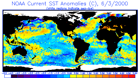
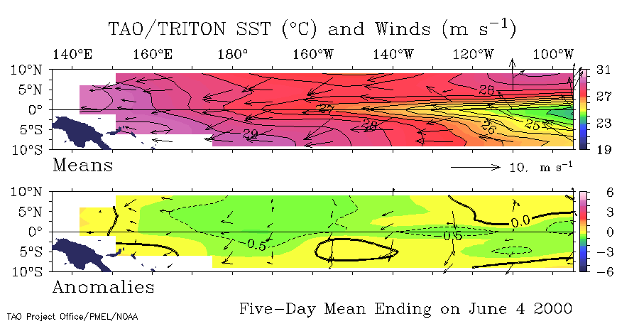
Sea Surface Temperatures (SST's) across the equatorial western and central Pacific are nearly neutral to about 0.5 degrees (C) below normal covering most of the length of the equator, but are a bit more concentrated in the region of the dateline. These cooler waters have been slowly working their way west for the past 3 months. From an anomaly perspective, the equatorial Pacific is somewhat warmer than what it was 3-4 months ago. And in April and May anomalously warm surface temperatures appeared on the equator in the Eastern Pacific, and looked very much like a typical El Nino. But those warm temperatures have since retreated and are now isolated to a small area hugging the coasts of Equator and Columbia. Trade winds are blowing at near normal rates from east to west, not enough to really sustain any significant cold upwelling in the equatorial eastern Pacific, but they certainly haven't changed directions, which typically occurs during the onset of El Nino events. Typical of this La Nina event, there are still two pronounced tongues of warm water in the western Pacific flowing north and south away from the equator towards Alaska and Chile. The southern flow has diminished significantly after having reached the whole way to the South American continent in February 2000, but the northern tongue is still well defined and extends to north of Hawaii with no indication of abatement. Locally, warmer than normal waters are present along the US west coast northward into Canada and Alaska, but not really typical of either El Nino or La Nina. In all, the water temperature conditions appears to indicate that though La Nina is no longer in control, the debris from it's presence over the past two winters has left it's mark and will be slow to shift.
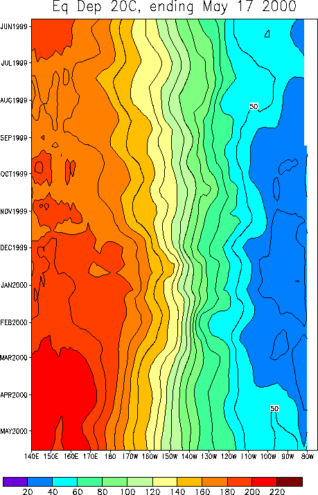
A key indicator in the evolution of either an El Nino or La Nina event is the depth of the 20 degree thermocline. During La Nina events, warm sub-surface water remains pooled up in the western Pacific, whereas in El Nino events, it migrates to the eastern Pacific. The 20 degree thermocline indicates that La Nina conditions still prevail with no indications that the pattern is starting to shift.
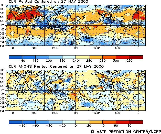
Outgoing Longwave Radiation (OLR) anomaly data (which measures cloud reflectivity/cloud cover) indicates dryer than normal conditions in the East Pacific (over the colder waters) and wetter than normal conditions in the west (over the warmer waters that better support evaporation), again indicative of La Nina.
The Southern Oscillation Index (SOI) which is used to compare relative barometric surface pressure between Darwin Australia and Tahiti continues to be solidly positive, indicating that high pressure still generally dominates the East and Central Pacific while lower than normal pressure dominates the West Pacific, again typical of La Nina.
LONG RANGE STORM AND SWELL DEVELOPMENT FORECAST
Summer 2000 Swell Potential Rating =
3.0
Fall/Winter 2000/2001 Swell Potential Rating = 5.0
For the summer of 2000, the probability for storm and swell development in the Pacific Ocean is still lower than normal. On a 1-10 scale, the storm potential rating is a 3.0 (10 being high probability for large swells and 1 being a low probability for large swells), much like the summer of 1999. But the probability for storm and swell development in the Pacific Ocean for fall into winter of 2000/2001 is expected to move up into the normal range with a rating of 5.0.
By winter of 2000/2001 the presence of abnormally warm sea surface water in the NW Pacific (off Siberia to nearly the Gulf of Alaska) is expected to dissipate and normal water temperatures are expected to return to the Pacific equator. The normal equatorial water temperatures should help to slightly dampen high pressure in the Gulf of Alaska and permit storms to travel further east of the dateline, unlike the winter of 1999/2000 where high pressure had a stronger than normal grip on the Gulf region and forced many storms into the Aleutian Islands, obscuring their swell producing winds. Of interest, in January 2000 the team at JPL remarked on the "horseshoe pattern" of warmer waters migrating northeast from Japan and southeast off New Guinea, suggesting this is part of a much longer range decadal pattern (more than just an isolated La Nina event). The winter of 200/2001 will be a good test of that theory.
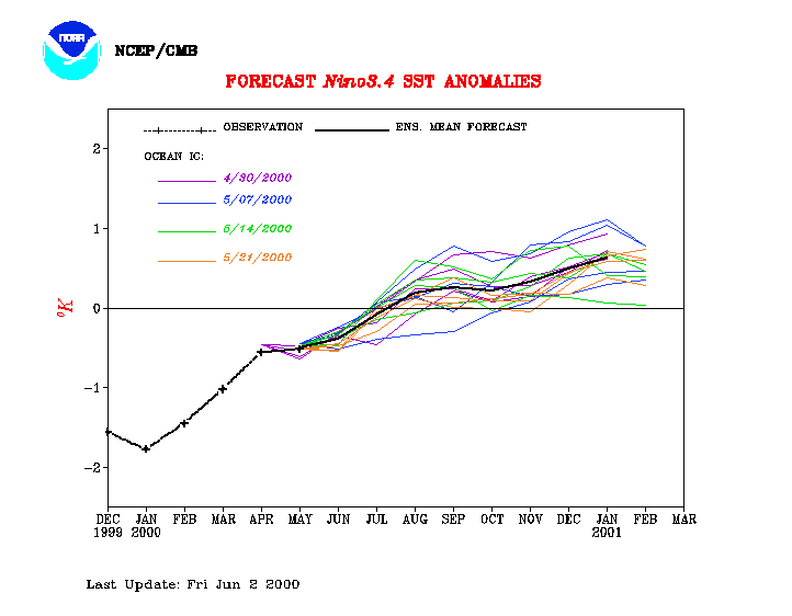
Sea surface temperature forecasts from NOAA/NCEP indicated a warming pattern to take hold in the late spring of 2000, but more recently in the summer of 2000. Models from other sources indicate only normal water temperatures or even cooler than normal temperatures for the same time period though. In short, any outcome you want to find exists in one of these models. But, considering that the Southern Oscillation Index continues to indicate moderate La Nina conditions (with no clear trend towards a change) and that the anomalously warm sub-surface water temperatures of the western Pacific have not started moving eastward, it seems unlikely that El Nino conditions would develop in the next 3 months. The Climate Prediction Center indicates that such a warm pool typically builds up for 1-2 years before an actual El Nino episode erupts. The slow fading of cool surface waters in the equatorial Pacific and it's progress westward are encouraging signs though.
(This forecast is highly speculative and based on historical analysis of past La Nina/El Nino events and the latest long-range forecast models)
Sea Surface Temperature Anomalies
Courtesy: NOAA
NESDIS
Only the faintest signs of cooler than normal waters on the equator are present in this
image, indicating that La Nina is fading. Also note small areas of normal to warm
water temps off the US West coast. But remnants of La Nina are present in the form
of warmer than normal waters off Japan and Siberia to north of Hawaii and also in the
South Pacific off Samoa and Fiji extending towards Chile, but fading (this is the
horseshoe pattern that JPL has mentioned). It looks as if La Nina breaking down.
 |
20 Degree Thermocline Depth Time
Series
Courtesy: CPC NCEP NOAA
Warm surface water remains firmly entrenched in the West Pacific and cooler than normal
water temperatures remains locked in the East Pacific.
 |
Sea Surface Temperature Anomalies
and Average Surface Winds on the Equatorial Pacific
Courtesy: NOAA PMEL
Notice only slightly cooler than normal SST conditions in the equatorial Pacific (0.5
degrees) positioned further west than in the past. Also notice near normal trade
winds, reducing upwelling in the east.
 |
Outgoing Longwave Radiation
(Average and Anomaly)
Courtesy: CPC/NCEP/NOAA
Notice higher than normal cloud reflectivity in the West Pacific, indicative of more
clouds and precipitation, and lower than normal reflectivity in the East Pacific,
indicative of relatively cloud free conditions.
 |
Equatorial Pacific Sea Surface
Temperature Forecast
Courtesy: NOAA/NCEP
Notice that 4 separate models runs (using different starting conditions) indicate water
temperatures over the Central Pacific are to return to normal about July of 2000,
but then some of the model runs push into warmer than normal conditions, indicative of
normal to slightly El Nino type conditions by September 2000.
 |
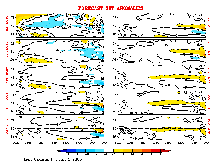
Equatorial Pacific Sea Surface Temp
Forecast
Courtesy: NCEP/CMB
Notice Sea Surface Temps are to remain slightly negative/below normal thru July 2000, then
go neutral and warm slightly by October of 2000.
 |
[an error occurred while processing this directive]
Comments?
webmaster@stormsurf.com