
EL NINO SOUTHERN OSCILLATION (ENSO) FORECAST
Updated As Warranted

EL NINO SOUTHERN OSCILLATION (ENSO) FORECAST
Updated As Warranted
Issued: 09/21/00
See ENSO page for Links and Current Data. ENSO Tutorial
NEUTRAL CONDITIONS
DOMINATE
No Change Forecast
Neutral conditions are currently in.cgiace across the oceans of our.cgianet, indicating neither El Nino or La Nina. The forecast models have stabilized, generally projecting a continuation of neutral conditions through the winter of 2000/20001.
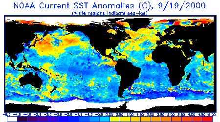
Of particular interest are anomalies in the seasonal adjusted average Sea Surface Temperatures (SST's) across the oceans. The waters of the southern hemisphere are much colder than normal, while the north hemisphere is much warmer than normal. The equatorial Pacific (from west to east) is generally near normal, with only slightly warmer than normal temperatures on either end and slightly cooler temperatures in the Central Pacific. In April and May anomalously warm surface temperatures appeared on the equator in the Eastern Pacific, and looked very much like a weak El Nino. But those warm temperatures retreated. A second flare-up of warm waters occurred again in July through early August, but again retreated. During this period the Southern Oscillation Index (SOI - which is used to compare relative barometric surface pressure between Darwin Australia and Tahiti) started indicating negative anomalies. This meant that lower than normal pressure was starting to build-in over the East and Central Pacific while higher than normal pressure was taking hold of the West Pacific, typical of a weak El Nino. But since then the pattern has reversed itself, and more La Nina-like conditions have again taken hold, with the SOI index moving solidly positive towards a La Nina-like pattern. In short, no clear pattern is developing towards either an El Nino or La Nina extreme.
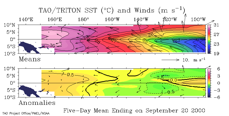
Pacific Equatorial trade winds are near normal, with just enough velocity to sustain some weak cold upwelling in the East Pacific, dampening any warm water buildup. The signature of the La Nina event or 1998-2000 were two pronounced tongues of warm water in the western Pacific flowing north and south away from the equator towards Alaska and Chile. The southern flow has completely diminished after having pushed warm water the whole way to the South American continent in February 2000, but the northern tongue is still well defined and extends across the entire North Pacific Ocean to the US (Washington) with no indication of abatement. Locally, a thin band at near normal water temperatures is present along the US west coast, but not really typical of either El Nino or La Nina. A pocket of very cold water is present in the eastern Gulf of Alaska. In all, the water temperature conditions appears to indicate that La Nina is fading and the oceans are trying to return to some state of equilibrium, but it looks like that will be some time in coming.
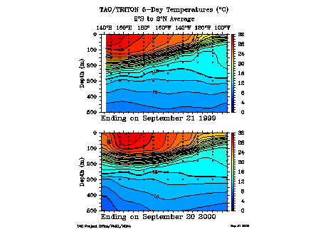
A key indicator in the evolution of either an El Nino or La Nina event is the depth of the 20 degree thermocline. During La Nina events, warm sub-surface water remains pooled up in the western Pacific, whereas in El Nino events, it migrates to the eastern Pacific. The most recent 20 degree thermocline profile indicates that La Nina conditions are fading, and that the core of the subsurface warm pool was made some progress eastward over the past year, but nothing dramatic.
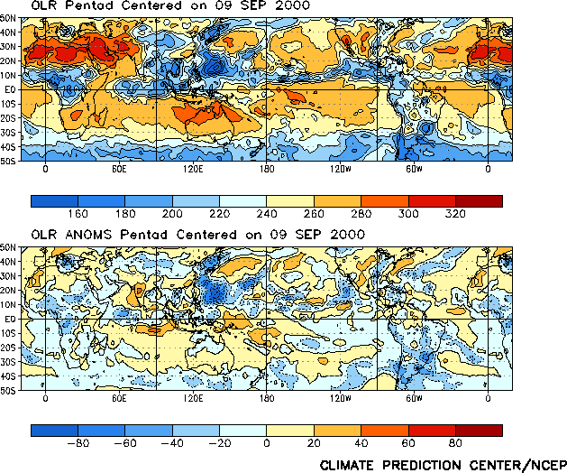
Outgoing Longwave Radiation (OLR) anomaly data (which measures cloud reflectivity/cloud cover) indicates dryer than normal conditions in the East Pacific (over the colder waters) and wetter than normal conditions in the west (over the warmer waters that better support evaporation), indicates only weak La Nina to near normal conditions.
LONG RANGE STORM AND SWELL DEVELOPMENT FORECAST
Fall/Winter 2000/2001 Swell Potential Rating = 4.5
For the winter of 2000/2001 the presence of abnormally warm sea surface water in the NW Pacific (off Siberia to Washington state) is expected to hold while near normal water temperatures are expected to slowly return to the Pacific equator. The normal equatorial water temperatures should help to slightly dampen high pressure in the Gulf of Alaska and permit storms to travel further east of the dateline, unlike the winter of 1999/2000 where high pressure had a stronger than normal grip on the Gulf region and forced many storms into the Aleutian Islands, obscuring their swell producing winds. Of interest, in January 2000 the team at JPL remarked on the "horseshoe pattern" of warmer waters migrating northeast from Japan and southeast off New Guinea, suggesting this is part of a much longer range decadal pattern (more than just an isolated La Nina event). The winter of 200/2001 will be a good test of that theory.
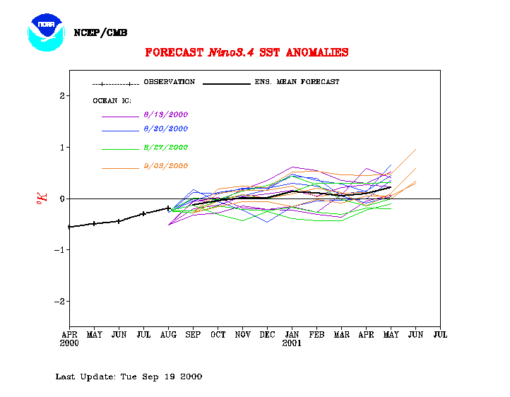
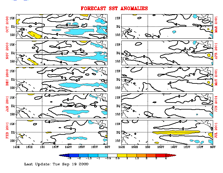
Sea surface temperature forecasts from NOAA/NCEP indicated a slow warming pattern to build through the winter and take hold in the late spring of 2001. This is consistent with models from other sources. Seeing that a slow trend towards anomalously warmer sub-surface water temperatures of the western Pacific have started moving eastward, it seems probable that normal to slight El Nino conditions could develop next year (20001). This is consistent with the Climate Prediction Centers data that indicates a warm pool typically builds up for 1-2 years in the western Pacific before an actual El Nino episode erupts.
(This forecast is highly speculative and based on historical analysis of past La Nina/El Nino events and the latest long-range forecast models)
Sea Surface Temperature Anomalies
Courtesy: NOAA
NESDIS
Notice much cooler than normal water temperatures in the south hemisphere and warmer than
normal temperatures in the northern hemisphere. On the equator in the Pacific, some
warm water is pooled up close to Central America, but cooler conditions prevail over the
Central Pacific. Warm water stretches from Japan to Washington.
 |
20 Degree Thermocline Depth and
Position Time Series
Courtesy: CPC NCEP NOAA
Warm surface water is still firmly entrenched in the West Pacific, but has made
significant eastward progress since last year.
 |
Sea Surface Temperature Anomalies
and Average Surface Winds on the Equatorial Pacific
Courtesy: NOAA PMEL
Notice only slightly cooler than normal SST conditions in the equatorial Pacific (0.5
degrees) positioned generally in the Central Pacific. Also notice near normal trade winds,
reducing upwelling in the east.
 |
Outgoing Longwave Radiation
(Average and Anomaly)
Courtesy: CPC/NCEP/NOAA
Notice slightly higher than normal cloud reflectivity in the West Pacific, indicative of
more clouds and precipitation, and lower than normal reflectivity in the East Pacific,
indicative of relatively cloud free conditions. But, these conditions are not nearly
as pronounced as even 3 months ago.
 |
Equatorial Pacific Sea Surface
Temperature Forecast
Courtesy: NOAA/NCEP
Notice that 4 separate models runs (using different starting conditions) indicate water
temperatures over the Central Pacific are to return to normal about October of 2000,
with a slight tendency to warmer than normal conditions by January 2001.
 |
Equatorial Pacific Sea Surface Temp
Forecast
Courtesy: NCEP/CMB
Notice Sea Surface Temps are to remain generally just below normal thru December 2000,
then go neutral and warm slightly by July 2000.
 |
[an error occurred while processing this directive]
Comments?
webmaster@stormsurf.com