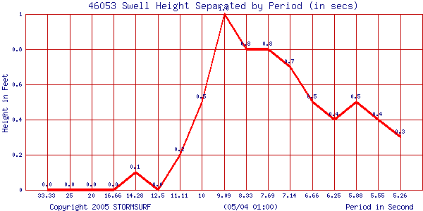
| Current Swell & Surf Analysis | | Buoy 46053 | | 10:00:00 (GMT) on 08/03 | | Sea Height: | 2.6 ft | | Primary Swell Height: | 1.6 ft | | Primary Swell Period: | 10.9 secs | | Surf Height | 1.4 ft |
Date
(Month/Day) | Time
(GMT) | Sea Height
[>5 secs]
(ft) | Primary Swell | Secondary Swell | Tertiary Swell | Estimated Surf Height (ft) | Primary Period (secs) | Height
(ft) | Period
(secs) | Height
(ft) | Period
(secs) | Height
(ft) | Period
(secs) | | 08/03 | 10:00:00 | 2.6 | 1.6 se | 10.9 secs | 1.4 se | 7.7 secs | 0.2 se | 14.3secs | 1.4 -1.7 | 10.9 | | 08/03 | 09:00:00 | 2.6 | 1.5 se | 10.1 secs | 1.3 se | 6.7 secs | 0.2 se | 14.3secs | 1.2 -1.5 | 10.1 | | 08/03 | 08:00:00 | 2.9 | 1.5 se | 11.1 secs | 1.4 se | 7.7 secs | 0.2 se | 14.3secs | 1.3 -1.6 | 11.1 | | 08/03 | 07:00:00 | 3.0 | 1.8 se | 10.1 secs | 1.4 se | 6.7 secs | 0.2 se | 14.3secs | 1.4 -1.8 | 10.1 | | 08/03 | 06:00:00 | 3.2 | 1.7 se | 10.0 secs | 1.6 se | 6.7 secs | 0.2 se | 14.3secs | 1.4 -1.7 | 10.0 | | 08/03 | 05:00:00 | 3.1 | 1.5 se | 11.0 secs | 1.7 se | 7.7 secs | 0.2 se | 14.3secs | 1.3 -1.7 | 11.0 | | 08/03 | 04:00:00 | 3.2 | 1.5 se | 10.1 secs | 1.9 se | 6.7 secs | 0.6 se | 13.8secs | 1.2 -1.5 | 10.1 | | 08/03 | 03:00:00 | 3.2 | 2.0 se | 8.4 secs | 0.8 se | 12.1 secs | 0.0 se | 0.0secs | 1.3 -1.6 | 8.4 | | 08/03 | 02:00:00 | 3.0 | 1.7 se | 9.9 secs | 1.6 se | 6.7 secs | 0.0 se | 0.0secs | 1.4 -1.7 | 9.9 | | 08/03 | 01:00:00 | 2.4 | 1.4 se | 9.1 secs | 1.2 se | 5.9 secs | 0.3 se | 12.5secs | 1.0 -1.3 | 9.1 | | 08/03 | 00:00:00 | 1.9 | 1.1 se | 10.0 secs | 1.0 se | 6.7 secs | 0.4 se | 13.4secs | 0.9 -1.1 | 10.0 | | 08/02 | 23:00:00 | 2.0 | 1.3 se | 9.1 secs | 0.5 se | 12.2 secs | 0.8 se | 5.9secs | 0.9 -1.1 | 9.1 | | 08/02 | 22:00:00 | 2.1 | 1.3 se | 10.0 secs | 1.1 se | 6.8 secs | 0.4 se | 13.2secs | 1.1 -1.3 | 10.0 | | 08/02 | 21:00:00 | 2.3 | 1.5 se | 9.2 secs | 0.7 se | 12.3 secs | 0.9 se | 6.0secs | 1.1 -1.4 | 9.2 | | 08/02 | 20:00:00 | 2.4 | 1.7 se | 8.4 secs | 0.7 se | 12.4 secs | 0.4 se | 15.9secs | 1.1 -1.4 | 8.4 | | 08/02 | 19:00:00 | 2.1 | 1.2 se | 9.0 secs | 1.1 se | 6.0 secs | 0.2 se | 12.5secs | 0.9 -1.1 | 9.0 | | 08/02 | 18:00:00 | 1.9 | 1.1 se | 8.3 secs | 0.5 se | 12.4 secs | 0.0 se | 0.0secs | 0.8 -0.9 | 8.3 | | 08/02 | 17:00:00 | 1.9 | 1.3 se | 7.7 secs | 0.7 se | 11.0 secs | 0.2 se | 14.3secs | 0.8 -1.0 | 7.7 | | 08/02 | 16:00:00 | 1.9 | 1.2 se | 8.4 secs | 0.4 se | 12.4 secs | 0.0 se | 0.0secs | 0.8 -1.0 | 8.4 | | 08/02 | 15:00:00 | 1.9 | 1.1 se | 9.1 secs | 0.4 se | 12.5 secs | 0.9 se | 5.9secs | 0.8 -1.0 | 9.1 | | 08/02 | 14:00:00 | 1.9 | 1.3 se | 8.4 secs | 0.4 se | 12.6 secs | 0.0 se | 0.0secs | 0.8 -1.1 | 8.4 | | 08/02 | 13:00:00 | 2.0 | 1.1 se | 9.1 secs | 1.1 se | 5.9 secs | 0.3 se | 12.5secs | 0.8 -1.0 | 9.1 | | 08/02 | 12:00:00 | 1.9 | 1.1 se | 8.4 secs | 0.5 se | 12.4 secs | 0.0 se | 0.0secs | 0.8 -1.0 | 8.4 | | 08/02 | 11:00:00 | 2.1 | 1.2 se | 8.4 secs | 0.4 se | 12.1 secs | 0.0 se | 0.0secs | 0.8 -1.0 | 8.4 |
Surf Height Scale| Size Scale (ft) | | >1 | 1-2 | 2-3 | 3-4 | 4-5 | 5-6 | 6-7 | 7-8 | 8-9 | 9-10 | 10-11 | 11-12 | 12-13 | 13-14 | 14-15 | 15-20 | 20-25 | 25-30 | 30-35 | 35-40 | 40-45 | 45+ |
Swell Period Scal| Period Scale (secs) | | 6.3 | 6.7 | 7.1 | 7.7 | 8.3 | 9.1 | 10 | 11.1 | 12.5 | 14.3 | 16.7 | 20 | 25 | 33.3 |
| Current Weather Conditions | | Buoy 46053 | | 10:50:00 (GMT) on 08/03 | | Combined Sea Height: | 3.9 ft | | Dominant Period: | 7.0 secs | | Wind Speed: | 5.8 kts | | Wind Gust: | 5.8 kts | | Wind Direction: | 250 degrees | | Barometric Pressure: | 1009.7 mbs | | Air Temperature: | 61.7 degrees | | Water Temperature: | 69.8 degrees |
24 Hour Weather Observation
Date
(Month/Day) | Time
(GMT) | Combined Sea Height (ft) | Dominant Period
(secs) | Wind Speed
(kts) | Gust
(kts) | Wind Direction
(degrees) | Barometric Pressure
(mbs) | Air Temperature
(F) | Water Temperature
(F) | | 08/03 | 10:50:00 | 3.9 | 7.0 | 5.8 | 5.8 | 250 | 1009.7 | 61.7 | 69.8 | | 08/03 | 09:50:00 | 3.9 | 10.0 | 9.8 | 11.7 | 250 | 1009.6 | 61.3 | 69.8 | | 08/03 | 08:50:00 | 4.3 | 10.0 | 11.7 | 13.7 | 240 | 1009.5 | 61.7 | 69.8 | | 08/03 | 07:50:00 | 4.6 | 6.0 | 11.7 | 15.6 | 240 | 1009.7 | 62.1 | 70.0 | | 08/03 | 06:50:00 | 4.9 | 7.0 | 13.7 | 15.6 | 250 | 1009.7 | 62.6 | 70.0 | | 08/03 | 05:50:00 | 4.9 | 7.0 | 15.6 | 17.6 | 260 | 1009.8 | 62.8 | 69.8 | | 08/03 | 04:50:00 | 4.9 | 7.0 | 13.7 | 17.6 | 240 | 1009.9 | 63.3 | 70.0 | | 08/03 | 03:50:00 | 5.2 | 7.0 | 15.6 | 17.6 | 250 | 1009.3 | 63.5 | 70.0 | | 08/03 | 02:50:00 | 4.9 | 10.0 | 17.6 | 19.5 | 240 | 1009.1 | 63.7 | 70.0 | | 08/03 | 01:50:00 | 4.3 | 10.0 | 15.6 | 17.6 | 260 | 1008.9 | 64.2 | 70.0 | | 08/03 | 00:50:00 | 3.6 | 10.0 | 13.7 | 17.6 | 270 | 1009.6 | 64.8 | 70.0 | | 08/02 | 23:50:00 | 3.3 | 9.0 | 13.7 | 15.6 | 260 | 1010.0 | 65.1 | 70.0 | | 08/02 | 22:50:00 | 3.6 | 9.0 | 13.7 | 15.6 | 260 | 1010.4 | 65.1 | 69.8 | | 08/02 | 21:50:00 | 3.6 | 10.0 | 11.7 | 13.7 | 270 | 1011.0 | 64.2 | 69.8 | | 08/02 | 20:50:00 | 3.3 | 8.0 | 11.7 | 13.7 | 260 | 1011.7 | 66.0 | 69.6 | | 08/02 | 19:50:00 | 3.3 | 9.0 | 7.8 | 9.8 | 220 | 1012.0 | 65.5 | 69.8 | | 08/02 | 18:50:00 | 3.3 | 8.0 | 3.9 | 7.8 | 250 | 1012.5 | 64.0 | 69.4 | | 08/02 | 17:50:00 | 3.3 | 9.0 | 5.8 | 7.8 | 250 | 1012.5 | 64.2 | 70.0 | | 08/02 | 16:50:00 | 3.0 | 7.0 | 3.9 | 5.8 | 270 | 1012.6 | 64.2 | 69.6 | | 08/02 | 15:50:00 | 3.3 | 8.0 | 1.9 | 3.9 | 190 | 1012.8 | 63.7 | 69.3 | | 08/02 | 14:50:00 | 3.0 | 7.0 | 5.8 | 5.8 | 210 | 1012.6 | 63.7 | 69.6 | | 08/02 | 13:50:00 | 3.0 | 8.0 | 5.8 | 7.8 | 240 | 1012.4 | 64.0 | 69.8 | | 08/02 | 12:50:00 | 3.6 | 9.0 | 7.8 | 9.8 | 230 | 1011.6 | 63.5 | 69.8 | | 08/02 | 11:50:00 | 3.6 | 8.0 | 9.8 | 11.7 | 230 | 1011.3 | 63.0 | 70.0 |
| 000109036 ___0.037376 | |