Surf Forecasts and Marine Weather - No Hype - Just the Facts!
Winter To Return as MJO Pulses! - Video Forecast HERE (3/17/24)
Buoys | Buoy Forecast | Bulletins | Models: Wave - Weather - Surf - Altimetry - Snow | Pacific Forecast | QuikCAST | El Nino | Tutorials | Great Circles | Video

Google

Stormsurf Mobile App

Create Your Own Surf Forecast
Swell Calculator
Swell Decay Tables
Sea Height Tables
Swell Category Table
Convert from GMT:
 
 to timezone:

---
Jason-3 Satellite Altimetry
Significant Wave Height Overlaid on Wavewatch III Wave Model

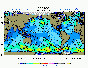
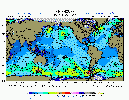
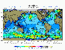
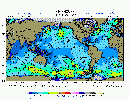
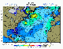
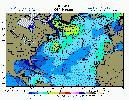
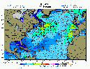
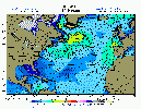
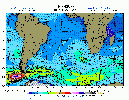
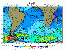
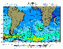
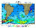
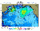
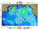
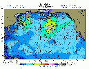
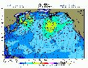
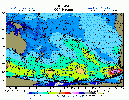
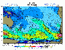
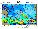
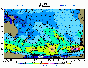
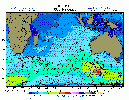
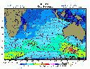
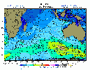
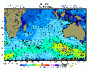
The Jason-3 satellite measures significant wave height accurate to within 4.2 centimeters. When that data is overlaid onto the Wavewatch 3 wave model, one can determine the accuracy of the wave model. The satellite may not pass over all areas for all time periods. Because we are using the quickest available Jason-2 data source, only gross error checking is performed so the altimetry data is inherently 'noisy'. All available altimetry data points are plotted and scaled using the models color scheme (in feet).

Read More Here - Frequently Asked Questions

Jason-3 Images
Click thumbs or icons to view full size images

Location
(west to east)
Latest Data 192 hr archive
- 00Z 06Z 12Z 18Z -
Global View Globe 00Z Altimetry Globe 06Z Altimetry Globe 12Z Altimetry Globe 18Z Altimetry Global Altimetry Archive Animation
- - - - - -
 Atlantic Ocean
North Atlantic North Atlantic 00Z Altimetry North Atlantic 06Z Altimetry North Atlantic 12Z Altimetry North Atlantic 18Z Altimetry North Atlantic Altimetry Archive Animation
Gulf of Mexico Gulf of Mexico 00Z Altimetry Gulf of Mexico 06Z Altimetry Gulf of Mexico 12Z Altimetry Gulf of Mexico 18Z Altimetry Gulf of Mexixco Altimetry Archive Animation
Tropics (Full) Tropical Atlantic 00Z Altimetry Tropical Atlantic 06Z Altimetry Tropical Atlantic 12Z Altimetry Tropical Atlantic 18Z Altimetry Tropical Atlantic Altimetry Archive Animation
Northwest Northest Atlantic 00Z Altimetry Northwest Atlantic 06Z Altimetry Northwest Atlantic 12Z Altimetry Northwest Atlantic 18Z Altimetry Northwest Atlantic Altimetry Archive Animation
Europe Europe 00Z Altimetry Europe 06Z Altimetry Europe 12Z Altimetry Europe 18Z Altimetry Europe Altimetry Archive Animation
South Atlantic South Atlantic 00Z Altimetry South Atlantic 06Z Altimetry South Atlantic 12Z Altimetry South Atlantic 18Z Altimetry South Atlantic Altimetry Archive Animation
Southwest Southwest Atlantic 00Z Altimetry Southwest Atlantic 06Z Altimetry Southwest Atlantic 12Z Altimetry Southwest Atlantic 18Z Altimetry Southwest Atlantic Altimetry Archive Animation
Southeast Southeast Atlantic 00Z Altimetry Southeast Atlantic 06Z Altimetry Southeast Atlantic 12Z Altimetry Southeast Atlantic 18Z Altimetry Southeest Atlantic Altimetry Archive Animation
Pacific Ocean
North Pacific North Pacific 00Z Altimetry North Pacific 06Z Altimetry North Pacific 12Z Altimetry North Pacific 18Z Altimetry North Pacific Altimetry Archive Animation
Japan Japan 00Z Altimetry Japan 06Z Altimetry Japan 12Z Altimetry Japan 18Z Altimetry Japan Altimetry Archive Animation
Northwest Northwest Pacific 00Z Altimetry Northwest Pacific 06Z Altimetry Northwest Pacific 12Z Altimetry Northwest Pacific 18Z Altimetry Northwest Pacific Altimetry Archive Animation
Northeast Northeast Pacific 00Z Altimetry Northeast Pacific 06Z Altimetry Northeast Pacific 12Z Altimetry Northeast Pacific 18Z Altimetry Northeast Pacific Altimetry Archive Animation
Tropics (West) Tropical West Pacific 00Z Altimetry Tropical West Pacific 06Z Altimetry Tropical West Pacific 12Z Altimetry Tropical West Pacific 18Z Altimetry Tropical West Pacific Altimetry Archive Animation
Tropics (Central) Tropical Central Pacific 00Z Altimetry Tropical Central Pacific 06Z Altimetry Tropical Central Pacific 12Z Altimetry Tropical Central Pacific 18Z Altimetry Tropical Central Pacific Altimetry Archive Animation
Tropics (East) Tropical East Pacific 00Z Altimetry Tropical East Pacific 06Z Altimetry Tropical East Pacific 12Z Altimetry Tropical East Pacific 18Z Altimetry Tropical East Pacific Altimetry Archive Animation
South Pacific South Pacific 00Z Altimetry South Pacific 06Z Altimetry South Pacific 12Z Altimetry South Pacific 00Z Altimetry South Pacific Altimetry Archive Animation
Southwest Southwest Pacific 00Z Altimetry Southwest Pacific 06Z Altimetry Southwest Pacific 12Z Altimetry Southwest Pacific 18Z Altimetry Southwest Pacific Altimetry Archive Animation
South Central South Central Pacific 00Z Altimetry South Central Pacific 06Z Altimetry South Central Pacific 12Z Altimetry South Central Pacific 18Z Altimetry South Central Pacific Altimetry Archive Animation
Southeast Southeast Pacific 00Z Altimetry Southeast Pacific 06Z Altimetry Southeast Pacific 12Z Altimetry Southeast Pacific 18Z Altimetry Southeast Pacific Altimetry Archive Animation
Indian Ocean
Indian Ocean Indian Ocean 00Z Altimetry Indian Ocean 06Z Altimetry Indian Ocean 12Z Altimetry Indian Ocean 18Z Altimetry Indian Ocean Altimetry Archive Animation
Southwest Southwest Indian Ocean 00Z Altimetry Southwest Indian Ocean 06Z Altimetry Southwest Indian Ocean 12Z Altimetry Southwest Indian Ocean 18Z Altimetry Southwest Indian Ocean Altimetry Archive Animation
Southeast Southeast Indian Ocean 00Z Altimetry Southeast Indian Ocean 06Z Altimetry Southeast Indian Ocean 12Z Altimetry Southeast Indian Ocean 18Z Altimetry Southeast Indian Ocean Altimetry Archive Animation

Available Jason-3 data overlaid onto WW3 hindcast images as soon as model data posted.
Additional altimetry data posted on subsequent WW3 runs.
Images archived into Adobe™ Flash animations once daily (about 04Z).

53886

.
Contact | About | Disclaimer | Privacy | Advertise/Content | Links Visit Mark Sponsler on Facebook Visit Stormsurf on Instagram Visit Stormsurf on YouTube
Copyright © 2023 STORMSURF - All Rights Reserved
This page cannot be duplicated, reused or framed in another window without express written permission. But links are always welcome without permission.
Buoys | Buoy Forecast | Bulletins | Models: Wave - Weather - Surf - Altimetry - Snow | Pacific Forecast | QuikCAST | El Nino | Tutorials | Great Circles | Calculator