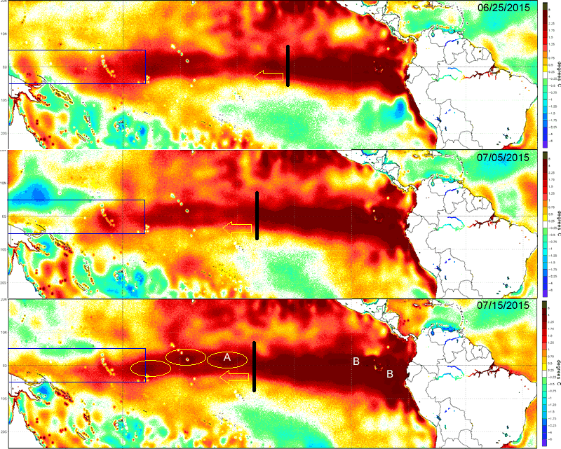
This page documents the current state of the Pacific tropics as of 7/15/2015 as it relates to the developing El Nino. It further suggests that warm surface waters migrating to the west in the Nino 3 & 4 regions might begin to get recirculated as they advect into Kelvin Wave Generation Area (KWGA - 135E to 170W between 3 degs N and S), resulting in a feedback loop that would superheat the existing subsurface warm pool, eventually upwelling and have an amplifying effect on the surface warm pool and ultimately the atmosphere. There is no documented evidence of this occurring in the past, and we're not saying this will happen. But it appears to be a possibility.
Figure #1
The below 3 hi-resolution images were taken 10 days apart between 6/25 and 7/15 and roughly depict the progression of anomalously warm water from the first Kelvin Wave of the season generated by a Westerly Wind (WWB) burst in March and perhaps the early arrival of water from a second WWB in early May. The solid black line depicts the westward most position of continuous water above 2.25 degs C. The yellow arrow depicts the direction of expansion. Note that expansion is not limited to just the west, but is also occurring to the north and south, though less so. The blue box identifies the KWGA, the origin of the WWB noted above. In the last image (7/15) circles (A) indicated building pockets of 2.25 deg C anomalies. Close inspection also reveal that in area (B) anomalies in excess of 4 degs C are building and backfilling waters migrating west, presumably fueling future expansion.
Images courtesy of NOAA/NW/NCEP/EMC at 0/083 x 0.083 deg C resolution.
Figure #2
This image (also from 7/15/2015) depicts the current state of subsurface waters of the equatorial Pacific. Arrow (A) depicts the downwelling of warm surface waters in the West Pacific driven by a significant WWB that occurred there from June 22-July15. Those waters are starting to concentrate at Arrow (B) where a small pocket of 3 deg C anomalies are depicted. This is the start of the third Oceanic Kelvin Wave of the year. Movement of those waters follows to Arrow (C) where the Kelvin Waves associated with WWB #1 & 2 have merged forming a broad subsurface reservoir of 5+ deg C anomalies that are impacting the Galapagos and Ecuador Coast and upwelling to the surface there. temps are confirmed at 4-5 deg above normal at the Galapagos. Trade winds (from the east) in that region are then carrying those waters to the West - see Arrow (D).
The question is: If these waters continue their westward expansion, will they continue migrating into the KWGA (as they appear to already be doing) and get pushed to depth as depicted by Arrow (E) by westerly anomalies already in play there? And will they then get recirculated through Arrows B & C only to re-emerge as another Kelvin Wave, or at least supercharging either Kelvin Wave #3 or yet another Kelvin Wave likely to develop associated with the next Active Phase of the MJO in August?
Image courtesy of NOAA/TAO/TRITON
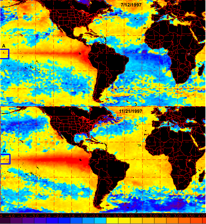
Figure #3
Two images from the record 1997 El Nino are provided depicting Sea Surface Temperature anomalies. The KWGA area is identified by Box A. As best as can be identified, water temps flowing into the KWGA reached only 1.0 degs on 7/12 and barely 1.5 degs by 11/21 at the peak of the event. As of the July 15th image for 2015 temps are +1.5-1.75 degs. Granted the images are far higher resolution today, and the color scales are different. But today's image clearly depicts a +2.25 deg pocket building on the eastern edge of the KWGA (leftmost circle A in Image #1 above). What happens if some of that superheated water get recirculated down into either the new developing downwelling Kelvin Wave in July or another possibly in August?