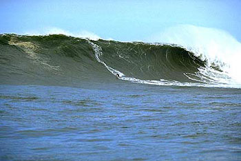
Biggest Wave Ever Ridden/Bradshaw at Outer Log Cabins
Storm 24 (1/28/98 - 1/30/98; Peak of the Largest El Nino on record)
Storm 24 generated the largest and meanest North Pacific swell in recent memory. It was the biggest storm during the biggest El Nino in recorded history, forming just off Siberia and taking a near straight track east across the North Pacific into the Gulf of Alaska. Swell 24 hit Hawaii on sunrise of January 28th 1998, and by late afternoon Ken Bradshaw had claimed the prize for riding the biggest wave of all time (tow-in at Outer Log Cabins). It was estimated at 80 ft on the face. Buoy 51001 reported seas 24.7 ft @ 20 secs with one reading (at 21 Z) to 27.5 ft @ 20 secs and decoded swell averaging 19 ft @ 20 secs with a peak of 23.6 ft @ 19.6 secs (21Z). Seventy five percent of that energy reached the Northshore of Oahu, with peak combined seas estimated at 18.5-20.6 ft and swell averaging 14.8 ft @ 20.8 secs with a peak of 17.7 ft @ 19.6 secs (at 21Z + 8 hrs).
Two days later in the early morning hours of Friday January 30th , Mavericks experienced the full fury of this swell. Tow-in surfing was not well established in Northern CA at the time, and only a few members of the paddle-in crew successfully made it out. Top honors went to Neil Matthies for taking the largest wave of the day. Riding his 11' 11" gun, he made a very late drop, only to get left behind the peak. His prize was a 2 wave hold-down and a trip through the rocks. Detailed spectral wave density data from buoy 46026 (San Francisco) indicated combined sea heights maxed at 2 AM at 20 ft @ 20 seconds, with largest swell size at 14.5 ft @ 18.8 secs (2 AM), 16.5 ft @ 18.7 secs (3 AM) and 13.4 ft @ 16.2 secs (9 AM). Face heights were 30-40 feet, with brisk offshore winds.
First Mavericks Tow Swell
Storm 1 (October 28, 1999; Building La Nina)
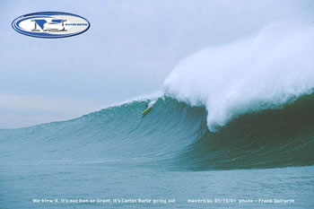
Two years later tow-surfing came to Mavericks in a very big way. Peter Mel watched from shore when Ken Bradshaw rode his epic wave at Outer Log Cabins, and used that inspiration to build his own tow routine back home in Northern California. During the start of a long La Nina cycle, he and Ken (Skinny) Collins had polished their act enough to try it at Mavericks. And what an first show it was. The first significant storm of the season, Storm 1 was the exact opposite of the massive El Nino storms. But what it lacked in size and duration it made up for in intensity and positioning. Forming on the afternoon of 10/26 relatively close to shore, it generated sustained winds up to 55-65 kts before it mowed right over buoy 46006 (SE Papa). There seas to 53.7 ft were reported aimed right at Northern CA. This produced seas at buoy 46012 (Half Moon Bay) at 18.0-21.8 ft @ 17 secs with decoded spectral wave density data indicating peak swell readings of 15.6 ft @ 18.5 secs (9 AM) to 16.7 ft @ 17.2 secs (11 AM) and 17.6 ft @ 15.7 secs (3 PM). This resulted in waves well into the 60+ ft range, and Peter and Ken had it essentially all to themselves.
 |
Peter Mel towed into what was then easily the largest wave ever ridden at Mavericks (10/28/99).
Photo © 1999 Frank Quirarte (mavsufer.com)
Cortez Bank Swell - Storm 15
(January 18 & 19, 2001; Strong La Nina)
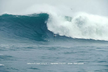
Storm 15 generated the thickest and best paddle swell in recent memory at Mavericks. Forming on January 14th over the dateline while tracking east just north of Hawaii, this storm covered a large fetch area with winds 50-60 kts and even up to 70 kts early in it's life, all aimed right at the California coast. The swell hit at 4 PM on Thursday the 18th with seas at buoy 46012 (Half Moon Bay) 11.6 ft @ 20 secs with decoded swell size 10.4 ft @ 22 secs and coming up through sunset. At the coast the swell was incredibly thick and powerful. As each set steam rolled through, the size and power step-laddered up. More and more riders were taken out by the nearly unrideable swells, and the pack dwindled. Lance Harriman suffered the worst wipeout on a late drop on a warping monster of a wave. He was pushed so deep underwater so fast he punctured his eardrum. Fortunately Jeff Clark was there on a jetski to provide a critical rescue. As the sun sank to the horizon the last of the paddle-in crew got out of the way while Jeff and Jay Moriarity towed into some monster waves in near total darkness. The last wave of the day saw Jeff getting a memorable dry tube. The swell peaked from 9 PM through till 1 AM with seas 13 ft @ 20 secs and swell ranging from 11.6-12.8 ft @ 20 secs.
By Friday morning the paddle-in crew was on it at first light. The swell had evened out a bit as the period dropped, with seas 11-12 ft @ 17-20 secs and swell at 10.6 ft @ 18.5 secs holding through noon. But an increasing offshore wind made for marginal conditions. Still , the paddle-in crew made a valiant try. Off the Southern California coast Pete and Skinny were towing into the epic waves at Cortez Bank. By early afternoon many riders were exhausted and the wind turned slight onshore. The pack thinned considerably. But by midafternoon the wind died, and the next session was on as ruler perfect 18-22 ft bombs poured over the reef. The swell was still very respectable with seas 12.4 ft @ 17 secs with swell 10.6 ft @ 17 secs, with 4-5 waves per set. Everyone out was getting their fill. Again at sunset, the paddle-in crew stepped aside to give Jeff and Jay a tow show. This time Jay got the tubing bomb, with the paddle-in crew watching from the sidelines. Everyone hooted, making for a fitting end to an epic swell.
 |
Carlos Burle paddling into a large and well lined up wall at Mavericks (1/19/01).
Photo © 2001 Frank Quirarte (mavsufer.com)
100 ft Wave - Storm 8
(November 21, 2001; Fading La Nina)
Storm 8 generated the largest swell on record, beating out the huge Hawaiian El Nino swell of 1/28/98. Forecast to be a rather local and moderate storm that was to track over buoy 46006 (SE Papa) like Storm 1 in 1999, what actually hit was beyond imagination.
Days earlier 2 storms were forecast to move in quick succession into the Gulf of Alaska. As expected, the first one developed and followed the forecast track, generating a swell that started to hit the outer SE Papa buoy (46006) on 11/19 at 11 AM with seas in the 20-23 ft @ 17 secs. This swell reached Mavericks the afternoon of November 20th with seas 13-14 ft @ 14-17 secs with swell 10.5 ft @ 15.5 secs, holding through the night. Nothing noteworthy but defiantly rideable at Mavericks. While the first storm took up residence in the Gulf and slowly faded, a second storm followed quickly in it's tracks on November 19th. It developed a small but relatively intense fetch area in it's south quadrant with winds at 55-60 kts blowing due east, carried by the jetstream and fueled by the moisture left behind by the first storm. These winds found lot's of traction at the oceans surface, already agitated from the earlier storm. The new storm also tracked east at a very fast pace, not allowing the developing seas to escape the influence of it's winds, piling more wave energy on top of an already large swell (virtual fetch). By the morning of 11/20 winds were still being recorded with speeds at 55-60 kts. The northern component of the resulting swell hit buoy 46006 at 9 AM and held through 7 PM with seas ranging 38.5-41.9 ft @ 17-20 secs, very large but not off the scale. Clearly, this buoy did not get hit with all the wave energy this storm had produced, with much of it passing south undetected. And buoy 46059 located 350 nmiles off Pt Reyes was out of service, further reducing the effectiveness of the normal early warning system.
Nearshore the situation got interesting. On the morning of 11/21, the swell from the first storm was still present at buoy 46012 (Half Moon Bay) with decoded swell at 12 ft @ 15 secs. As expected, by 10 AM the second swell started to build in with combined seas 16.4 ft and the new swell at 11.1 @ 20 secs and increasing rapidly. The paddle-in crew was out cautiously catching some bombs as the swell jumped in size with each passing set. The tow teams waited in the channel for their chance to strike. By noon they got their chance as the last paddle surfers were cleaned out and increasing south winds took a toll on conditions. Combined seas were 19.6 ft @ 20 secs with solid energy out to 25 secs and swell 14.1 ft @ 19 secs. One hour later swell was up to 14.9 ft @ 19 secs. By now the tow teams were only shoulder hopping the huge sets that were pouring over the reef while south winds set up a strong northerly crosschop. Even so, Carlos Burle managed to snag the biggest wave of the year, measured at 68 ft on the face. The swell was interacting with the 15 second swell already present, creating huge waves breaking way outside the normal outermost reefs. By 2 PM the new swell was up to 16.3 ft @ 19 secs, then up to 19.3 ft @ 21 sec one hour later. Shawn Alladio was out in the channel on a jetski at Mavericks and reported nearly being taken out by a set of waves the largest being upwards of 100 ft. Based on the buoys, even larger waves followed after she made it safely to shore. By 5 PM the largest decoded swell reading hit, with swell at 19.9 ft @ 19.4 secs and combined seas to 23.98 ft. Whitewater was visible out to the horizon at most coastal locations, and longtime locals reporting breaks they had never seen were going off, but way beyond anything that would be classified as rideable.
 |
Carlos Burle towed into this bomb of a wave early in the swell of November 21, 2001 at Mavericks. Even larger and meaner waves broke that afternoon, with no one in sight.
Photo © 2001 Frank Quirarte (mavsufer.com)
