Hurricanes serve the same purpose as winter storms, they vent off heat from the lower levels of the atmosphere. In summer months near the equator, ocean temperatures rise as the sun continually beats down on it. Once ocean water temperature approach 80 degrees (F) evaporation increases dramatically, causing large amounts of warm humid air to rise up from the ocean surface. As it rises, perhaps up to 15,000 ft or more, it starts to cool. The humidity condenses and falls out as cold rain. The rain in-turn cools the ocean surface and equilibrium is restored.
But if sufficient heat and moisture is present, the rainstorm continues to push higher into the atmosphere, maybe to 22,000 ft, and a thunderstorm forms. After a few hours of good rain and lightning, equilibrium normally is restored. But sometimes so much latent heat energy is present in the ocean and atmosphere that the storm persists for days. This in combination with the presence of a pre-existing upper level circulation, pushes the moisture higher into the atmosphere, pulling more warm air up even higher and starts the system to circulate. Because the air under the thunderstorm is rising, surface air pressure drops. Air from around the storm rushes in to fill the void left by the rising air, causing wind. But all this serves to do is drag more warm moist air into the system, fueling yet more growth in term of size and height. As the storm grows it starts to circulate faster. Rotation is counterclockwise in the north hemisphere and clockwise in the south. As it grows, central pressure continues to drop and wind speed increases. The storm also moves, normally from east to west, directed by the flow and presence of high pressure systems aloft. Once wind speeds reach about 90 kts, an 'eye' can form. This small cloud free area located in the center of the storm develops due to extreme uplifting of air, much like smoke rising up out of a chimney, clearing the center of the storm of clouds. It can range from a few miles to 40 miles in diameter. An 'eyewall' forms around the eye, consisting of very dense clouds and the highest velocity winds.
 |
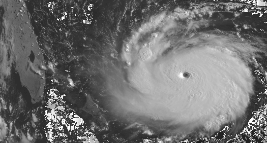
Hurricane Fran, 9/4/1996
Enhanced Infrared Image
Image Courtesy: NOAA
Hurricanes are notorious for being 'unpredictable' though. They can stall, speed ahead, fall apart or strengthen quickly in response to rapidly changing events occurring in the upper atmosphere. Tropical systems with sustained wind speeds of less that 34 kts (39 mph) are called Tropical Depressions. When wind speed near the center of the storm reaches sustained speed of 34 kts (39 mph) it's called a Tropical Storm. Once sustained winds reach sustained speeds of 64 kts (74 mph) they are classified as hurricanes. Maximum sustained winds can reach as high as 175 mph. Theres much reference data available on the web regarding the formation and characteristics of tropical systems (see here).
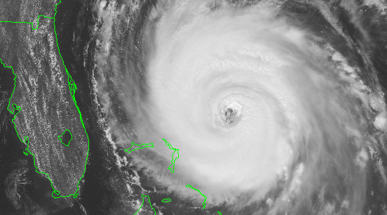
Hurricane Andrew
POES Visible Image
Image Courtesy: NOAA
From a surf forecast perspective, hurricanes are capable of producing large waves of moderate period (13-14 secs) if a variety of conditions are right. Typically the storm needs to be headed right towards your location, with maximum winds over a multi-day period. Fetch area is normally small compared to winter storms, with winds greater than 30 kts rarely extending out more than 250 nmiles from the center of circulation. But if the storm is headed right at you with a constant heading over several days, it is possible to develop a good amount of 'virtual' fetch, effectively increasing the fetch area and improving the chances for a longer period swell (14-17 secs). But then the risk of the storm actually hitting your location increase too. It's much like playing a game of dodge-the-bullet. Conversely, if the storm is moving perpendicular or away from you, there is no probability for virtual fetch, and the chances for swell decrease dramatically.
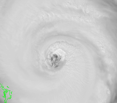 |
Hurricane Fran, 9/4/1996
Visible closeup image of the eye.
Image Courtesy: NOAA
Tropical storms can produce swells not only in the tropics, but well north too. Normally hurricanes track around the edges of large summer high pressure systems that develop in the central Atlantic and Pacific Oceans (in either hemisphere). In both the north Atlantic and Pacific, as tropical storms approach the western most point of these oceans, if they don’t hit land or die out, they turn towards the north. As they progress northward, and eventually northeastward, they loose their tropical characteristics. They move over colder waters off the north Atlantic/Pacific and transform from being warm core to cold core, and turn extra-tropical. Extra-tropical systems generally will increase in size and fetch area, though winds will back off a bit. Regardless, they can in-turn take tracks towards Europe or Canada, producing nearly winter like storm surf in the early fall.
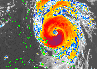
Hurricane Fran, 9/4/1996
GOES8 Visible Image
Image Courtesy: NOAA
The normal atmospheric and wave models are of limited use when trying to predict strength and heading and swell sizes associated with tropical systems. Rather, building a solid historical base from past experience becomes an essential skill from predicting swell size and arrival times of tropical systems. Using a map, plot all the information you can obtain (position, wind speed, central pressure, and wind field size, distance from your location etc) for every advisory issued. Use this data to build a your own estimate of swell arrival time and size, then compare the results to what actually happens. With time, accuracy of your forecast should increase.
NEXT |