Swell Classification Guidelines
Significant: Winter - Swell 8 ft @ 14 secs or greater (11+ ft faces) for 8+ hours (greater than double overhead).
Summer - Head high or better.
Advanced: Winter - Swell and period combination capable of generating faces 1.5 times overhead to double overhead (7-10 ft)
Summer - Chest to head high.
Intermediate/Utility Class: Winter - Swell and period combination generating faces at head high to 1.5 times overhead (4-7 ft).
Summer - Waist to chest high.
Impulse/Windswell: Winter - Swell and period combination generating faces up to head high (1-4 ft) or anything with a period less than 11 secs.
Summer - up to waist high swell. Also called 'Background' swell.
PACIFIC OVERVIEW
Current Conditions
On Tuesday (6/3) in North and Central CA local windswell was producing waves in the chest high range and lightly chopped by south winds at exposed breaks. Down in Santa Cruz wrap around windswell was producing waves in the knee to occasionally thigh high range on the sets and clean. In Southern California up north local north windswell was producing waves at knee high on the sets with textured conditions. Down south windswell was wrapping in producing gutless waist high sets with textured if not lightly chopped conditions. Hawaii's North Shore was flat and clean. The South Shore was getting minimal background southern hemi swell with waves waist to chest high on the sets and a little warbled from sideshore wind. Exposed breaks on the East Shore was getting knee high windswell with weak southeasterly trades adding some chop on top.
See QuikCASTs for the 5 day surf overview or read below for the detailed view.
Meteorological Overview
No swell producing fetch is occurring or forecast for the North Pacific other than local windswell. For the southern hemisphere a gale developed on the very eastern edge of the SCal swell window on Wed (5/28) with 38 ft seas pushing east, targeting mainly Chile. Low odds of sideband swell for SCal on Thurs (6/5). A weak gale formed southeast of New Zealand on Sat-Sun (6/1) with 36 ft seas aimed east. Small background swell to result for HI by the weekend and up into CA next week. Nothing else is on the charts.
Details below...
SHORT- TERM FORECAST
Current marine weather and wave analysis.cgius forecast conditions for the next 72 hours
North Pacific
Overview
Surface Analysis - On Tuesday (6/3) trades were below the minimal 15 kt threshold relative to Hawaii offering no generation potential for east windswell there. Modest high pressure at 1028 mbs remain locked off Oregon generating a weak pressure gradient and north winds at 20 kts along the North CA coasts generating small local short period north windswell for Central CA down to Pt Conception. Over the next 72 hours high pressure is to push closer to the North CA coast with the gradient rebuilding and north winds 25 kts centered near Cape Mendocino Wednesday building to 30 kts Thursday and Friday producing a little larger local north short period windswell at exposed breaks mainly north of Pt Conception. Trades to hold in close proximity east of Hawaii at 15 kts through Fri (6/6) but not getting any coverage between the mainland and the Islands. Maybe some minimal short period east windswell is possible for exposed east facing shores.
North Pacific Animations: Jetstream - Surface Pressure/Wind - Sea Height - Surf Height
Tropics
No tropical systems of interest are forecast or being tracked at that time.
California Nearshore Forecast
On Tuesday AM (6/3) high pressure at 1030 mbs was locked in the Eastern Gulf of Alaska off Oregon ridging towards North CA with 20 kt north winds in control of waters off Cape Mendocino, with a eddy flow (south winds) over Southern CA reaching up into Central CA. The gradient is forecast to rebuild on Wed (6/4) with 30 kt north winds over Cape Mendocino late increasing in coverage some on Thursday with an eddy flow nearshore for Central and South CA. More of the same Friday, Saturday and Sunday, with the gradient building in coverage on Monday and holding into mid-next week.
South Pacific
Overview
Jetstream - On Tuesday (6/3) the jetstream was .cgiit with the two streams running parallel to each other across the entire South Pacific. A ridge was pushing south in the southern branch of the jet under New Zealand overrunning the Ross Ice Shelf with no odds to support gale development in lower levels of the atmosphere there. To the east a weak trough was positioned over the Central South Pacific but with only 90 kts winds feeding up into it, offering little in terms of support for gale development in lower levels of the atmosphere. And east of there (over the Southeast Pacific) another ridge was pushing hard south into Antarctica suppressing gale development over the entire Southeast Pacific. Over the next 72 hours the same basic pattern is to hold but with an semblance of a trough in the Central Pacific fading out meaning no support for gale development. Beyond 72 hours the southern branch of the jet is to turn pure zonal running flat west to east and repositioned south near the 622S latitude line, running just north of the northern edge of the developing Antarctic Ice Sheet and offering nothing in terms of support for gale development.
Surface Analysis - On Tuesday (6/3) swell from a gale that developed in the far Southeast Pacific (see Southeast Pacific Gale below) on Wed (5/28) was supposedly pushing north, holding only minimal hope for swell for the most exposed breaks in Southern CA. And swell from a gale that formed under New Zealand on Fri-Sat (5/31) was pushing northeast targeting Hawaii and the US West Coast (see New Zealand Gale below).
Over the next 72 hours no other swell producing weather systems are forecast.
Southeast Pacific Gale
A gale developed Tues PM (5/29) in the far Southeast Pacific with 45 kt west winds and 32 ft seas developing at 61S 130W pushing east. 45 kt southwest winds built into Wed AM (5/28) targeting Chile and about ready to move out of the CA swell window with 38 ft seas at 60S 120W and on the 180 degree path to SCal. 40+ kt southwest winds held into the evening again targeting South Chile with 38 ft seas at 58S 111W, outside the CA swell window. By Thurs AM (5/29) southwest winds were fading from 40 kts with 36 ft seas over a decent area at 47S 106W targeting only Chile. The gale is to be gone after that.
Maybe some bare minimum sideband swell for Southern CA starting Thurs AM (6/5) with swell 1.6 ft @ 19 secs (3 ft). Swell fading Fri AM (6/6) from 1.5 ft @ 17-18 secs (2.5 ft). Swell Direction: 175-180 degrees
New Zealand Gale
A gale organized southeast of New Zealand on Fri PM (5/30) with 35-40 kt southwest winds developing over a small area. By Sat AM (5/31) 35-40 kt southwest winds were over a broader area with 34 ft seas developing at 60S 180W (191 degs HI, 209 degs SCal and 207 degs NCal and shadowed relative to both. 45 kt west-southwest winds developed in the evening with seas building to 36 ft at 56S 169W (186 degs HI, 203 degs SCal and unshadowed and 205 degs NCal and shadowed by Tahiti). This system faltered after that on Sun AM (6/1) with winds dropping from 40 kts and seas 31 ft at 53S 155W (202 degs SCal and 200 degs NCal and unshadowed for both). A quick fade followed in the evening with seas fading from 28 ft at 53S 150W (200 degs SCal, 198 degs NCal and unshadowed). Limited southern hemi swell possible for all locations.
Hawaii: Expect swell arrival on Sat (6/7) building to 1.9 ft @ 17 secs (3.0-3.5 ft) late. Swell fading Sun (6/8) from 2.0 ft @ 15-16 secs (3.0-3.5 ft). residuals on Mon (6/9) fading from 2 ft @ 14-15 secs (2.5-3.0 ft). Swell Direction: 192 degrees
California: Expect swell arrival at sunset on Mon (6/9) with period 18+ secs. Swell to 1.35 ft @ 18 secs (2.5 ft) for exposed breaks. Swell to peak late Tues morning (6/10) at 1.5 ft @ 16-17 secs (2.5 ft). Swell holding at 1.6 ft @ 15-16 secs (2.5 ft) on Wed (6/11), then fading from there. Swell Direction: 208 degs SCal, 206 degs NCal
South Pacific Animations: Jetstream - Surface Pressure/Wind - Sea Height - Surf Height
LONG-TERM FORECAST
Marine weather and forecast conditions 3-10 days into the future
North Pacific
Beyond 72 hours high pressure is to hold it's position with north winds building to near 35 kts over Cape Mendocino into Tues-Wed (6/11) with windswell coming up some. The coverage of the 30+ kt north winds is to be limited to Northern California with a high likelihood of south eddy winds in control of Central CA down into Southern CA. Trades relative to Hawaii are to start building in coverage on Sat (6/7) fully extending from California the whole way over Hawaii in the 15 kt range with the most continuous coverage starting Monday with limited small east windswell possibly for east facing shores of the Islands.
MJO/ENSO Update
Note: The Madden Julian Oscillation is a periodic weather cycle that tracks east along the equator circumnavigating the globe. It is characterized in it's Inactive Phase by enhanced trade winds and dry weather over the part of the equatorial Pacific it is in control of, and in it's Active Phase by slack if not an outright reversal of trade winds and enhanced precipitation. The oscillation occurs in roughly 20-30 day cycles (Inactive for 20-30 days, then Active for 20-30 days) over any single location on the.cgianet. During the Active Phase in the Pacific the MJO tends to support the formation of stronger and longer lasting gales resulting in enhanced potential for the formation of swell producing storms. During the Inactive Phase the jet stream tends to .cgiit resulting in high pressure and less potential for swell producing storm development. The paragraphs below analyze the state of the MJO in the Pacific and provide forecasts for MJO activity (which directly relate to the potential for swell production).
As of Tuesday (6/3) the daily Southern Oscillation Index (SOI) was down some at 12.23. The 30 day average was up some at 7.33 and the 90 day average was rising slightly at 0.77. The near term trend based on the 30 day SOI was indicative of a neutral phase of the MJO trending Inactive. The longer term pattern was indicative of a neutral Phase of the MJO. The SOI tends to be a lagging indicator running a week behind surface level weather trends.
Current equatorial surface wind analysis indicated dead neutral anomalies over the Maritime Continent turning very weakly westerly near the dateline. Weak easterly anomalies developed south of Hawaii returning to a neutral pattern from there to the Galapagos Islands. A week from now (6/11) weak easterly anomalies are forecast north of Australia fading east of there but redeveloping on the dateline, turning moderate south of Hawaii then fading to neutral over the Galapagos and into Central America. In all this suggests perhaps a building Inactive Phase of the MJO a week out. Interestingly, starting 5/19 the TOA array started suggesting that solid westerly anomalies were in.cgiay near 160E, then faded to light westerly anomalies later in the period (5/27-5/30) then faded to neutral by 6/3. This is much better than what the GFS 850 mb data (which is actually 4,500 ft above surface level) would suggest. The sensors on the TOA buoys are 'hard data' literally on the oceans surface. And the buoys in this region are in good health. So no east wind anomalies have yet been experienced on the oceans surface. This is a good sign.
A previous WWB created a large Kelvin Wave tracking towards South America in January (starting 1/8, peaking 1/28 then fading the first week of Feb) followed by a second strong WWB in Feb-Mar (as strong as the first one starting 2/15 and peaking 2/20-3/2 then fading 3/10) setting up and offering yet more reinforcing transport warm water east. And then a third weak westerly wind burst developed (starting 3/12 and faded out by 3/28). And a fourth weaker one started 4/7 and held through 4/20, and was strong enough to be considered a minimal Westerly Wind Burst WWB. As of right now all this does not mean El Nino is in.cgiay. Still the pattern is something more than coincidental and strongly suggests some degree of pattern change has developed for the tropics. Of historical note: The big El Nino's of '82/32 and '97/98 both started forming in the February timeframe and progressed non-stop through the Summer and Fall months. A article presenting a Comparison between the genesis of the 1997 El Nino and this 2014 WWB event has been posted here.
The longer range models (dynamic and statistical) run on 6/2 are in sync. They both suggest a weak Inactive Phase of the MJO was present north of New Guinea and was fading fast. Looking forward both models suggest the Inactive Phase is to fade over the next 5 days out with a dead neutral pattern setting up 7 days out and holding 15 day into the future. And if anything, a modest Active Phase of the MJO was building in the Indian Ocean and is to try and ease east 15 days out, but fading all the while. The ultra long range upper level model suggests the Inactive Phase is already over the East Pacific and is to be inland by June 8 over South America. At the same time a very weak version of the Active Phase of MJO was already over the dateline and is to be tracking east into June 23, with secondary Active potential over the equatorial Pacific through July 4. A new weak Inactive Phase to follow. In all the pattern is to be very weak and weakening more. A very weak MJO pattern is what one would expect if an El Nino were to develop - namely that the MJO would all but disappear. That is the hallmark of El Nino. Now that we've effectively moved out of the Spring Unpredictability Barrier, the development of a weak to non-existent MJO pattern would be right on-time and expected. For the 5 months of 2014, pushing out of the Spring Unpredictability Barrier, there has been only one Inactive Phase, and based on TAO array data, no east anomalies of interest ever developed in the prime Kelvin Wave generation area - very good news. The upper level model tends to be a leading indicator, with surface level anomalies lagging behind 1 week or more.
The more warm water in the equatorial East Pacific means more storm production in the North Pacific during winter months (roughly speaking). Cold water in that area has a dampening effect. Regardless of what the atmospheric models and surface winds suggest, actual water temperatures are a ground-truth indicator of what is occurring in the ocean. As of the most recent imagery (6/2), a warm water regime continues building from Ecuador west over the Galapagos and drifting west from there peaking at 3.0 degs C above normal with a more modest warm pool ranging at +1.0 deg C range extending west from there to the dateline with +0.5 deg anomalies reaching 5 degrees north and south of the equator. There are embedded warmer pockets in the +1.5 deg C range. Of notice is markedly warmer water building down into Peru and up into Southern Central America with its core between the Galapagos and Ecuador forming the the signature warm El Nino triangle (it started being obvious on 5/1). This pattern became pronounced as of the 5/19 update and has been building every since. A new (to us) hi-res SST monitoring site depicts +3.0 deg anomalies embedded in the triangle between the Galapagos and Ecuador and trailing off of Peru in small pockets. This is the 'breech point' of a large Kelvin Wave that has been lurking just below the surface and built by consecutive Westerly Wind burst Jan-April. The larger equatorial warming pattern started in earnest on 3/29 and has been solidifying it's grasp every since, and is being fed by the Galapagos warm pool. Comparing this years event to the '97 El Nino event, water temps still are not approaching the warmth or coverage of the '97 event.
On 5/28 we performed a more detailed analysis of water term anomalies in the May 20 to May 25 timeframe comparing water temp anomalies of all other El Nino's from 1951 to present. The theory being the earlier the signature warm pool develops, the stronger it will become, because the more latent heat energy there is stored in the ocean. Surprisingly we actually found reanalysis date going back to 1951. One should view data prior to about '75 with much skepticism. We compared total areal coverage of warmer than normal waters on the equatorial Pacific and down the Ecuador and Peruvian coasts, and the coverage of warmers water in the direct vicinity of the Galapagos. Here's the results: the '97, '57 and '72 El Nino's beat the 2014 data, and ultimately ended up producing a 5 month running mean sea surface temp anomaly of +2.2, +1.8 and +1.6 degs C respectively. This 2014 event beat the next contending El Nino, the one of '65, which resulted in +1.6 degs anomalies. So from a statistical/historical perspective, this developing 2014 event should result in a SST anomaly of about +1.6 degs or the 4th strongest in the past 61 years. This is a theory that will be put to the test over the next 5 months. Data from the '82 El Nino is provided even though it had no contending footprint in the May timeframe because it ultimately resulted in SST anomalies of 2.0 degs above normal (5 month running mean). Also data from the '2009 El Nino is provided just because it was recent and likely still in most folks memories. So to have any warmer than normal water in the Nino 3.4 region in May (the Spring preceding when El Nino is declared) puts this 2014 event is an outlier category, presumably meaning some degree of a significant El Nino is developing. There is much variability between El Nino events, and not all are configured identical. That becomes apparent just inspecting the May '82 and '97 data. Two Super El Ninos, resulted, but with 2 different signatures early on. What's interesting is the configuration of this 2014 event is very similar to that of the 3 El Ninos ranked higher than it, all which produced significant results in the Fall and Winter months.
Strongest El Nino's
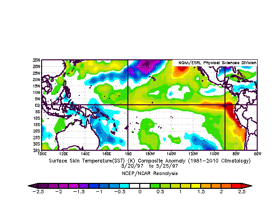
May 20-25 1997 SST Anomalies
(Greaterst ever - Ranked #1 for this time of year - +2.2 deg C final) |
May 20-25 1957 SST Anomalies
(Greater than 2014 - Ranked #2 for this time of year - +1.8 deg C final) |
 |
 |
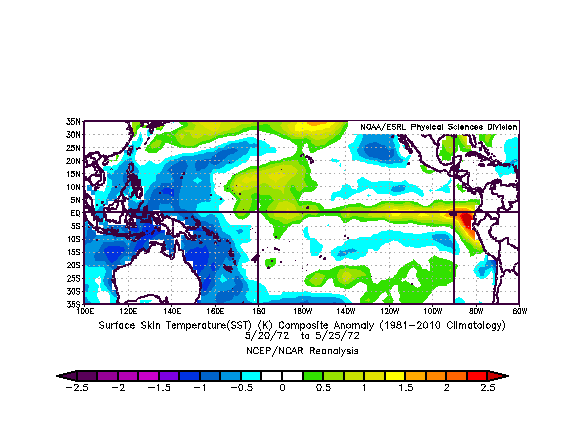
May 20-25 1972 SST Anomalies
(Greater than 2014 - Ranked #3 for this time of year - +1.6 deg C final) |
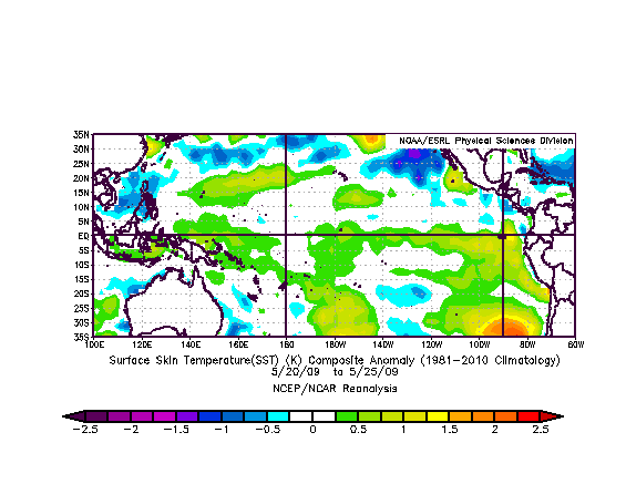
May 20-25 2014 SST Anomalies
(Ranked #4 for this time of year - ?? deg C final) |
 |
 |
Lesser El Ninos
(in May)
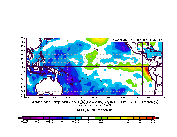
May 20-25 1965 SST Anomalies
(less than 2014 - Ranked #5 for this time of year - +1.6 deg C final) |
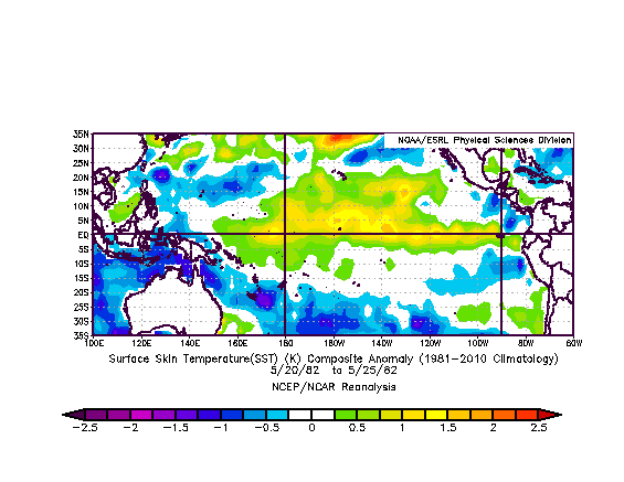
May 20-25 1982 SST Anomalies
(far less than 2014 for this time of year-+2.0 deg C final ) |
 |
 |
May 20-25 2009 SST Anomalies
(provided only for reference - Unranked - most recent El Nino - +1.4 deg C final ) |
|
 |
|
Elsewhere the entire North Pacific Ocean is full of warmer than normal water as is the West Pacific (north and south). There is only the weakest signs of high pressure induced upwelling streaming southwest off California, as would be expected for this time of year. This is significant. And the only cool water present is streaming off Southern Chile pushing west almost reaching up to the equator, but getting shunted south by the warm water on the equator. Overall the total amount of warmer than normal water in the North Pacific is impressive. A sympathetic warm pool that was developing off equatorial West Africa is showing signs of weakness with the most recent update. But all eyes remain on the developing breech of warm water along the western coast of Ecuador as a gauge of what's to come atmospherically.
Subsurface waters temps on the equator remain solid. Of great interest is a large area of warm +3-5 deg C above normal water in.cgiace and tracking east with it's core 150 meters down somewhere near 115W. As best as can be identified this Kelvin Wave covers the area from 180W to Ecuador with the core between 120 and 90W. The leading edge is impacting Ecuador and the Galapagos. Given the lack of sensors between 155W and 110W, exact details concerning the core of the Kelvin Wave remain sketchy, but the leading edge waters temps are not in doubt. The Kelvin Wave has also been confirmed via satellite in the form of increased surface water heights at +10 cm extending from Peru over the Galapagos and tracking east from there (5/23), with +5 cm anomalies extending west to the dateline. This suggests warm water at depth is di.cgiacing the surface upwards. Also data from the TOA array suggests warm water has be assimilated into the warm pool from a 4th WWB in April. So for now the warm pool has received some more energy. And some weak westerly anomalies continue being reported by the TOA array west of the dateline in May (see above). Still, another legit WWB is required.
The Pacific equatorial surface counter-current (from 5N to 2S from the Philippines to the Galapagos) as of 5/28 was strongly anomalously tracking west to east, typical of an El Nino configuration. But the June 1 data looked less impressive, as if the current might be starting to react to the previous reduction in Westerly Anomalies west of the dateline. We'll continue monitoring this indicator closely.
Based on previous history, an evolving El Nino would follow this general pattern: A large Kelvin Wave will erupt along the South American coast in May-June, and the increase in water temps in that area should reduce trades above it (by reducing surface air pressure), which in turn could support yet more warm water build-up (heated by the sun and through reduced upwelling). As a result, another series of WWB's should develop in the West Pacific in late Summer/early Fall fueled by warm water tracking west from the initial eruption site over the Galapagos further reducing trades in the West Pacific and resulting in more eastward moving warm subsurface water(i.e. Kelvin Waves). A feedback loop could develop, reinforcing the warm water flow and buildup off Central America into the Fall. But we're a long ways from that occurring just yet. What is needed is another Westerly Wind burst or at least continued westerly anomalies. Anything that reduces or suppresses trades in the equatorial West Pacific will suffice to continue the transport mechanism. So out-and-out west surface winds are not required. Anything that reduced trades in the east (like increasing water temps) will continue to stabilize the warm pool that is hopefully evolving there.
Projections from the CFSv2 model run 6/3 have retrograded some. It now suggests water temps building to +1.0 deg C by early August peaking at +1.5 deg C by Nov 2014 (down from a peak previously forecast at +1.75). Our guess is that some form of El Nino warning could be declared in the early June timeframe if all stays on track.
Previously a pattern of mult.cgie strong Westerly Wind Bursts occurred Jan-March 2014, but then moderated in late March, but never gave way to a fully Inactive Phase (with no hint of easterly anomalies west of the dateline) till early May. A neutral pattern developed May 5 and held through the end of May. This is great news with westerly anomalies in.cgiay for 4 full months and then only turning neutral in May. Longterm this signal (suppressed trades in the far equatorial West Pacific) will have to hold into at least August with warm water building greater than 0.5 deg C over the tropical East and Central Pacific (120W to 170W) for 3 consecutive months before one could declare the development of El Nino, though that already appears to be the case. Seeing how we're effectively through the Spring Unpredictability Barrier and no total collapse of the pattern has occurred, it looks like things are stabilizing in favor of El Nino. But nothing is certain until we hit August and see some redevelopment of WWBs over the dateline.
Overall the immediate outlook remains unchanged, but potentially trending towards something that would be considered warm by June-July 2014, assuming one is to believe the models and the subsurface water configuration. At a minimum the ocean is well past recharge mode, with cold water from the 2010-2011 La Nina dispersed and temperatures on the rise in fit's-and-starts. Regardless of the WWBs etc, we are in a neutral ENSO atmospheric pattern at this time with neither any form of El Nino or La Nina present or imminent. But given all current signs, atmospheric transition should begin in June over the equatorial Pacific possibly increasing during the summer, intensifying into Fall. Still there remains 3 months ahead where any number of hazards could derail this event. But this is a better.cgiace than previous years (2010-2011, 2011-2012 and 2012-2013) under the direct influence of La Nina. And it seems apparent we've recovered from the 2009-2010 El Nino. In a normal situation one would expect there to be at least one or two years of neutral temperatures ultimately converging in a stronger warmer pattern and possible El Nino 2-3 years out (2015 or 2016). Historically, this is the 'normal' pattern (a few years of false starts post La Nina before a legit El Nino forms). We've turned the corner, but we'll remain cautious and not say to much yet, especially in light of what appears to be a decadal bias towards a cooler regime (since 1998).
See imagery in the ENSO Powertool and more details in the El Nino Update Updated 12/4/13
See a 'Comparison between the genesis of the 1997 El Nino and the 2014 WWB Event' Here (posted 4/5/2014)
South Pacific
Beyond 72 hours no swell producing weather systems are forecast.
Details to follow...
****
External Reference Material: El Nino Southern Oscillation (ENSO), Madden Julian Oscillation (MJO), Pacific Decadal Oscillation (PDO), Southern Oscillation Index (SOI), Kelvin Wave
Add a STORMSURF Buoy Forecast to your Google Homepage. Click Here:

Then open your Google homepage, hit 'edit' button (top right near graph), and select your location
Local Interest
Updated - Stormsurf Video Surf Forecast for the week starting Sunday (6/1) - http://www.youtube.com/watch?v=Ok62U5rNe70&feature=youtu.be&hd=1
For automatic notification of forecast updates, subscribe to the Stormsurf001 YouTube channel - just click the 'Subscribe' button below the video.
- - -
 |
Casa Noble Tequila If you are looking for an exquisite experience in fine tequila tasting, one we highly recommend, try Case Noble. Consistently rated the best tequila when compared to any other. Available at BevMo (in California). Read more here: http://www.casanoble.com/ |
Mavericks Invitational Pieces Featuring Stormsurf:
http://www.bloomberg.com/video/how-to-predict-the-best-surfing-waves-EsNiR~0xR5yXGOlOq2MqfA.html
http://www.cbsnews.com/videos/surfs-up-for-mavericks-invitational-in-calif/
Time Zone Converter By popular demand we've built and easy to use time convert that transposes GMT time to whatever time zone you are located. It's ion left hand column on every page on the site near the link to the swell calculator.
Stormsurf Google Gadget - Want Stormsurf content on your Google Homepage? It's si.cgie and free. If you have Google set as your default Internet E.cgiorer Homepage, just click the link below and a buoy forecast will be added to your Google homepage. Defaults to Half Moon Bay CA. If you want to select a different location, just click on the word 'edit', and a list of alternate available locations appears. Pick the one of your choice. Content updates 4 times daily. A great way to see what waves are coming your way!
http://www.google.com/ig/add?moduleurl=http://www.stormsurf.com/gadget/stormsurf .xml
Free Stormsurf Stickers - Get your free stickers! - More details Here
Read all the latest news and happenings on our News Page here
Surf Height-Swell Height Correlation Table
